Aspen Maps and Orientation
(Aspen, Colorado - CO, USA)
An upmarket resort attracting some of the world's most affluent skiers and winter sports enthusiasts, Aspen functions as a self-governing town. Located in the state of Colorado and within Pitkin County, the town dates back to the late 1870s and is the important county seat.
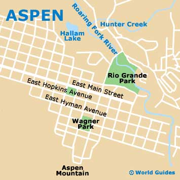
The Aspen Mountain is nothing short of an iconic resort and resides on East Durant Avenue, on the southern side of town and close to Wagner Park.
Reached along Prospector Road on the far southwestern side of town is the Aspen Highlands resort, which tends to be favored by both locals and the more experienced of skier. Elsewhere, Buttermilk is found to the northwest, the Snowmass Village to the west and the Snowmass Mountain to the southwest, where the USA's longest vertical drop awaits skiers.
Maps and Orientation of the City
Getting around Aspen is relatively easy, although during the harsh winter weather, the icy roads can prove somewhat treacherous. Most visitors headed to the ski resorts therefore favor the buses laid on by the Roaring Fork Transit Authority, although if you would like to self-navigate, then maps can be obtained from the Aspen Visitor Center (Chamber Resort Association) on Rio Grand Place, which is within the vicinity of the Pitkin County Library and the Ski Service Center.
The aptly named Main Street (the Colorado State Highway 82) serves as the town's principal thoroughfare, roughly dividing Aspen into two regions, north and south. East Main Street ultimately becomes East Cooper Avenue, while West Main Street leads onto West Hallam Street.
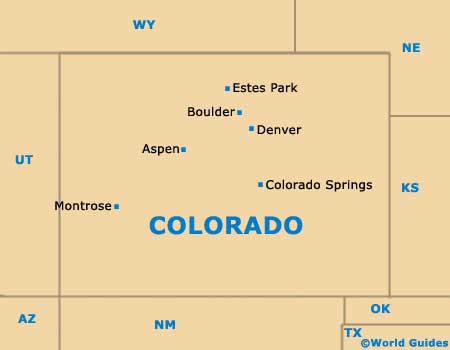
- Basalt - 20 miles / 32 km (30 minutes, northwest)
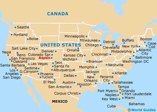
- Boulder - 219 miles / 352 km (five hours, northeast)
- Carbondale - 30 miles / 48 km (50 minutes, northwest)
- Champion Mill - 55 miles / 89 km (one hour and 30 minutes, east)
- Colorado Springs - 242 miles / 389 km (six hours and 30 minutes, southeast)
- Denver - 198 miles / 319 km (five hours and 15 minutes, northeast)
- Estes Park - 238 miles / 383 km (six hours and 20 minutes, northeast)
- Meredith - 20 miles / 32 km (30 minutes, northeast)
- Montrose - 139 miles / 224 km (three hours and 45 minutes, southwest)
- Nast - 18 miles / 29 km (30 minutes, northeast)
- Norrie - 18 miles / 29 km (30 minutes, northeast)
- Snowmass Village - 8 miles / 13 km (15 minutes, west)
- Woody Creek - 8 miles / 13 km (15 minutes, northwest)
Map of the United States
Map of Colorado
Map of Aspen